Chapter 4. Maps Class 6 Geography Solutions English Medium-Additional Questions
Chapter 4. Maps Class 6 Geography Solutions English Medium-Additional Questions Get chapter-wise detailed explanations, step-by-step answers, important questions and exam-ready study material in Hindi and English medium.
Topics Covered In This Article
Chapter 4. Maps Class 6 Geography Solutions English Medium-Additional Questions, NCERT Solutions for CBSE Board Classes 6 to 12, ncert solutions for all classes, NCERT SOLUTIONS, online NCERT solutions, NCERT, ncert, ncert solutions, ncert solutions for board exams, ncert Maths solution, Mathematics, ncert science solutions, ncert English book solutions, ncert Hindi book solutions, ncert Social Science book solutions, ncert accounts book solutions, Computer Education, solved question answer for all exercise
Chapter 4. Maps Class 6 Geography Solutions English Medium-Additional Questions
NCERT Solutions for Class 6 are specially prepared according to the latest CBSE syllabus (2026-27) to help students understand every concept clearly. These solutions provide step-by-step explanations, accurate answers, and exam-oriented guidance for all chapters. Class 6 students can improve their problem-solving skills, strengthen conceptual understanding, and prepare confidently for school as well as board examinations. All questions are solved in a simple and easy-to-understand language for both Hindi and English medium learners.
Chapter 4. Maps Class 6 Geography Solutions English Medium-Additional Questions
NCERT Solutions Class 6 Geography English Medium
Chapter 4. Maps
Topic: Additional Questions
Additional Question:
Que: When do you use a globe?
Ans: We use a globe when we want to study the earth as a whole.
Que: What is an antlas?
Ans: An atlas is a collection of maps.
Que: What do physical maps show?
Ans: Political maps show natural features of the earth such as mountains, plateans, plains, rivers, oceans, etc.
Que: What do political maps show?
Ans: Political maps show cities, towns and villages and different countries and state of world with their boundaries.
Que: What do you mean by a thematic map?
Ans: A map which gives focus on specific information is konwn as thematic map. For example, road maps, maps showing distribution of industries, etc.
Que: Differentiate between a small scale maps and a large scale map.
Ans:
(i) A small scale map is used to show large areas like continents or countries on a paper while a large scale map is used to show area such as village or town on a paper.
(ii) A large scale map is more informative than a small scale map.
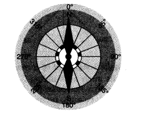
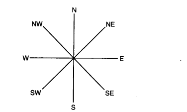
Que: What is called the northline?
Ans: Maps usually contain an arrow marked with the letter 'N' at the upper right hand comer. This arrow shows the north direction and is called the north line.
Que: What is a compass?
Ans: A compass is an instrument used to find out main directions.
Que: What are conventional symbols?
Ans: Some symbols have a fixed meaning and are understood uniformally through out the world. Such symbols are known as conventional symbols.
Que: What colours are used for the following:
(i) mountains
(ii) plain
(iii) plateaus
(iv) water bodies
Ans:
(i) Mountains - Brown colour
(ii) plains - Green
(iii) plateaus - yellow
(iv) water bodies - Blue
Que: What is a sketch map?
Ans: A sketch map is a rough drawing of an area. It is draw without scale.
Que: What is plan?
Ans: A paln is a drawing of a small area on a large scale.
Que: Differentiate between scale map and a large scale map.
Ans:
(i) A small scale map is used to show large areas like continents or countries on a paper while a large scale map is used to show a small area such as village or town on a paper.
(ii) A large scale map is more informative than a small scale map.
Que: What are cardinal points and intermediate directions?
Ans: The four major directions - North, South, East and West are called cardinal points. Beside these major directions we have intermediate directions - North - East (NE), South - East (SE), south - West (SW) and North - West (NW). The intermediate directions are very helpful in locating any placce more accurately.
Que: Write a note on 'compass'.
Ans: The direction of a place is traced out with the help of a compass. It is an instrument Used to find our main directions. It magnetic needle always points towards north - south direction.
Que: Define and discuss 'distance' as a component of a map.
Ans: Maps are drawing. They reduce the whole world or a part of it to fit on a sheet of paper. In other words we ca say that maps are drawn to reduced scales. but it needs great care while doing this reduction work in order to keep the distance between the real places. It can be possible when a small distance on paper represents a large distance on the ground. For this purpose a scale is used.
Scale is the between the actual distance on the ground and the distance shown on the map. We can understand this with the help of an example. Suppose, the distance between your coaching centre and your school is 8km. If you show this 8km distance by 2cm on a map. It means, 1cm on the map will show 4km on the ground. Thus, the scale of your drawing will be 1cm = 4km scale is very important in any map.
If scale is known, calculation of distance between anyb two places on a map will be easy. A small scale is used to show large areas on a paper like continents or countries. For example, 10cm on the map shows 1000km of the ground. A large scale is used to show a small area like a village or town on paper. For example, 10cm on the map shows 1000 metres only on the ground.
Que: GIve an account of 'direction' as a major component of a map?
Ans: Direction is an important component of a map. Most maps contain an arrow marked with the letter 'N' at the upper right hand comer. This arrow show the north direction. It is called the north line. After knowing the north direction, other directions, east, west and south can be easily found out.
There are four major directions - North, South, East and West. They are called cardinal points. Besides these, there are four intermediate directions. They are north - east (NE), south - east (SE), south - west (SW) and north - west (NW). Location of any place with more accuracy can be possible with the help of these intermediate directions.
:
Que: Discuss symbols as a major component of a map.
Ans: Drawing different features such as building, roads, etc. in their actual shape and size on a map is perhaps not possible, it is therefore, they are shown by using certain letters, shapes, colours, pictures and lines. These are symblos that give a lot of information is a limited space.
With the use of these symbols, maps can be drawn easily and are simple to read. These symbols help us greatly in a situation when don't know the language of an area and therefore cannot ask someone for directions. We can collect information from maps with thw help of these symblos.
Maps have a universal language known and understood by all. There is an international agreement regrading the use of these symbols, which are known as conventional symbols.
All Topics From Chapter 4. Maps
NCERT Solutions Class 6 Hindi and English Medium – Complete Study Material
NCERT Solutions Class 6 students ke liye specially CBSE latest syllabus (2026-27) ke according prepare kiye gaye hain. Yeh solutions Hindi aur English medium dono ke liye available hain, jisse har student apni language preference ke hisaab se padh sakta hai. Har chapter ke sabhi prashnon ke step-by-step answers diye gaye hain jo concept clarity aur exam preparation me madad karte hain.
Chapter-Wise Detailed Explanations
Class 6 ke liye diye gaye Chapter Wise NCERT Solutions me har question ka detailed aur easy explanation diya gaya hai. Chahe aap CBSE Board Exam Preparation kar rahe ho ya school test ke liye revise kar rahe ho, yeh solutions aapko complete understanding denge. Har answer simple language me likha gaya hai jisse students concepts ko easily grasp kar saken.
Hindi and English Medium Support
Students Hindi aur English medium dono me NCERT Book Solutions Class 6 access kar sakte hain. Yeh dual language support un students ke liye helpful hai jo apni regional language me better samajhna chahte hain. Sabhi answers CBSE Latest Syllabus 2026-27 ke anusaar update kiye gaye hain.
Important Features of NCERT Solutions
- Class 6 NCERT Solutions PDF
- CBSE Class 6 Study Material
- NCERT Book Questions and Answers
- Exam Oriented Important Questions
- Step-by-Step Detailed Solutions
- Concept Clarity and Revision Notes
Why Students Should Use NCERT Solutions?
Aaj ke competitive environment me sirf textbook padhna kaafi nahi hota. NCERT Solutions for Class 6 students ko practice aur conceptual understanding dono provide karte hain. Yeh solutions unhe exam pattern samajhne, frequently asked questions practice karne aur high score achieve karne me madad karte hain. Regular practice se students apne weak topics ko improve kar sakte hain.
Best Resource for Exam Preparation
Agar aap Class 6 CBSE Preparation ke liye ek trusted aur reliable source dhundh rahe hain, to yeh NCERT Solutions perfect choice hain. Yeh study material school exams, unit tests, half-yearly aur annual exams ke liye equally useful hai. Har chapter ke answers accurate, verified aur student-friendly format me diye gaye hain.
Isliye agar aap NCERT Solutions Class 6 Hindi and English Medium search kar rahe hain, to yahan aapko complete chapter-wise solutions milenge jo aapki academic journey ko strong aur confident banayenge.